Category: Technology Information

  • Hackitt Report & BIM Compliance

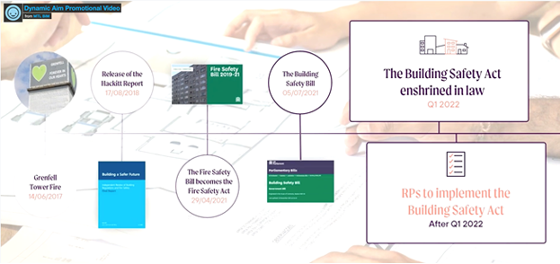
    The Hackitt Report covers the design, construction and maintenance of high-rise residential buildings.

    Transparency of data information and an audit trail thorough the lifecycle of a building from the planning stage to occupation and maintenance is essential to provide reassurance and evidence that a building has been built safe and continues to be safe.


    Local Authorities and Housing Associations are facing increasing legislation, compliance and safety challenges that are stretching the asset management capabilities of their current technology and operational procedures. Each are searching for a way to applying these principles to the existing stock of complex high-rise residential buildings as well as new builds. That is a moral obligation to those who are now living in buildings which they bought or rented in good faith assuming them to be safe and where there is a reason to doubt that. This will take time, be impeded by COVID19 restrictions and there will be a cost attached to it.


    Although a cost-efficient solution to this problem is beyond the scope of the Hackitt Report review to determine how remedial work is funded. Several Local Authorities and Housing Associations have been experimenting with 3D BIM Asset surveys of their properties to help accomplish the recommendations of the Report.

    https://youtu.be/PETe799bmDs

    Golden thread of building information

    The Hackitt review has identified that a ‘golden thread’ of good quality information will enable building owners to better manage their buildings safely. As soon as detailed work commences the client needs to ensure that a digital record of the building work is established, and a Fire and Emergency File is initiated. Both of these will need to be maintained throughout design and construction and be part of the regulatory oversight process.


    The Digital Record across the building lifecycle 

    The Hackitt review recommends that for new builds, a Building Information Modelling (BIM) approach should be phased in. BIM takes the digital techniques pioneered in other industries such as aerospace and automotive and applies them to construction. It is a process of designing, constructing or operating a building or infrastructure asset using electronic, object-orientated information. 


    It also forms part of the wider move towards improved transparency and integrity of information and underpins a greater focus on effective change control. Duty holders using the digital record effectively can more easily keep a log of the as-built design of the building and the products used in order to satisfy the JCA, before occupation begins. 


    Since April 2016, government has required BIM level 2 on centrally procured projects. This was a target established in the 2011 Government Construction Strategy. The government BIM level 2 mandate was a huge driver for digital record keeping. maturity of the UK construction industry has now grown to be able to deliver digital asset data, and increasingly work in a BIM compliant way. 


    The Hackitt Review and BIM Reality

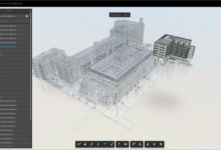
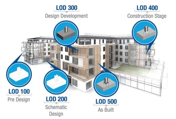
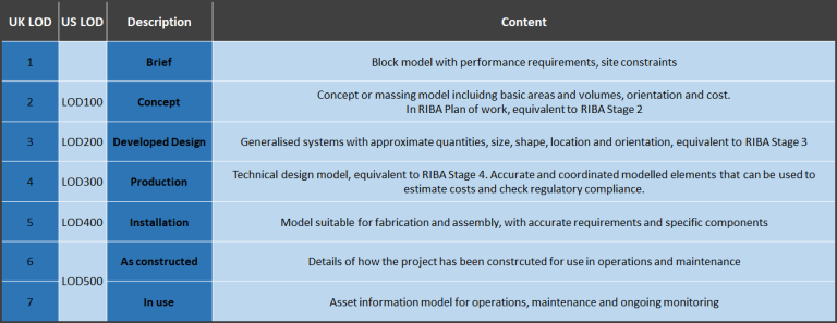
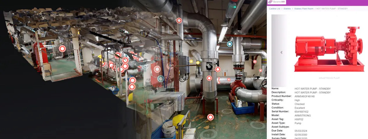
    During our journey, we had to revisit and completely understand what actually constitutes ‘Building Information Modelling (BIM)’. We discovered that BIM can be delivered to different levels of complexity depending on the Asset Management and compliance requirement which in turn can be categorised against building stock types. This empowers you to select which building types and indeed which individual elements of the building core that require highly detailed BIM to REVIT 3D Scans weighted against which building types or individual elements of a building can be simply 3D Photo scanned. A combination of these techniques can be consolidated within a single 3D BIM confederated Model.
    For more detailed information about BIM and levels of complexity
    Refer to associated Blog ‘What is Building Information Modelling (BIM)’


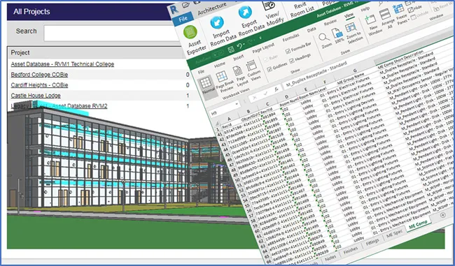
    3D BIM Laser Scanning is fast becoming the industry norm for precision surveying in high precision and high value asset environments. As one of the first to adopt 3D BIM Laser Scanning technology, we have evolved 3D BIM Scanning techniques using a Geo-location light weight 3D Digital Wrapper App that enhances (in preference to disrupting) your existing property, asset management solutions or working procedures. This tool empowers you to embrace full 3D BIM Models for new builds and also enables you the freedom to conduct plus host new 3D BIM & Asset Surveys for existing building stock. For 5 years, BIM level 2 has been mandatory on new buildings, but the subsequent BIM Model is often delivered on a disc or online within share-point or similar environments and the asset data is embedded within Cobie. A busy Facility Manager with a large property portfolio does not have the desktop tools or experience to find or use this large data so we found that offering a 3D Digital Wrapper App – light weight, easy to use GIS, Digital viewing tool with dynamic documents provides the ultimate 3D BIM to FM enabler.


    Hackitt Review & 3D BIM implementation Learnings

    Adopting BIM from a Digital Transformation perspective gives Local Authorities and Housing Associations a daunting challenge with a resolution options that can be summarised as follows:

    1. Adapt your existing Digital Technology and processes to link to BIM
      Bespoke development route
    2. Replace your current Digital Technology and processes with new Solutions
      Start again and throw away the old solutions and working procedures
    3. Adopt a light weight ‘add on’ 3D Digital WrapperApp (Asset Connector) to host BIM
      Immediately available as a proven BIM Solution from the BIM experts
    4. Try and consolidate your Assets through a 3rd party supplier
      Lose control of your assets


    We opted as 3D BIM and Software development experts to adopt option 3 as it would work for multiple organisations providing the ‘golden thread’ framework as a building block to your current Digital technology and business processes. This option also causes minimal Digital Transformation disruption but most importantly is the most cost- efficient approach.

    In 2020, working with several Local Authorities and Housing Associations leveraging a small percentage of precious business as usual budgets, we delivered and tested option 3.

    Once the 3D Digital WrapperAPP is signed off in discovery mode, the Digital Record across the building lifecycle using BIM can subsequently be phased in across multiple sites or buildings to include design, construction, building operation and infrastructure asset levels.

  • What is Building Information Modelling (BIM)?

    Building Information Modelling (BIM) is being widely prescribed as being mandatory for legislation and compliance including the Hackitt Report. With such drivers it is worth taking time to study what actually constitutes BIM.


    What is BIM?

    Building Information Modelling (BIM) is a process supported by various tools, technologies and contracts involving the generation and management of digital representations of physical and functional characteristics of places.


    Building information models (BIMs) are computer files (often but not always in proprietary formats and containing proprietary data) which can be extracted, exchanged or networked to support decision-making regarding a built asset.


    Having delivered successful BIM Models to many industry sectors over the last 24 months, I have come to realise that 3D BIM Models can be delivered to similar levels of asset detail using different cameras, processes and techniques. AutoDESK puritans would expect a 3D Revit Model with embedded Cobie data assets but these models are too complex, too big for the average Facility Manager and too expensive to implement on a large, diverse property portfolio.


    Several different techniques can be utilised when creating an effective BIM Model when you need to cover both new and existing building stock. More importantly, you can categorise your buildings, select the required technique/technology so that you can make significant savings on BIM Surveys across your portfolio with zero degradation on asset data quality and still be 100% compliant to legislation.


    BIM can involve the creation of a REVIT Model or indeed be a simple Laser or photo scan producing a less complicated 3D BIM Models where assets are tagged into a database or hyperlinked manually into CAFM/IWMS/PAMS/CMMS etc. The difference being that the latter suits the 3D surveying of site and external building areas (using drones or BLK360 cameras) the interiors of houses, flats or office interiors (using Matterport cameras).


    New Buildings v Existing Buildings

    New building projects such as the new Hammersmith & Fulham Town Hall are designed and developed in BIM REVIT from concept to completion whereas Existing Buildings have the traditional CAD files, assets and documents stored in siloed solutions often lacking key information.


    A New building will be delivered with a full, comprehensive BIM Model and the secret is to have somewhere where you can geo navigate to buildings to gain access to advanced BIM Viewer technology. You can then without any training visit the 3D BIM Model as a layman to view, steal or upload the asset data sets that you require without having to manage any change management procedures.


    Your BIM service provider can provide a hyper-link to the 3D BIM model so you and colleagues can visit the site 24 x7 using such as a 3D Digital Wrapper App.

    Lidar scan to BIM includes Revit conversion

    Existing Buildings – Lidar scan to BIM includes Revit conversion

    Existing Buildings – Lidar scan to BIM includes Revit conversion

    To complete a full BIM Survey on an Existing Building is possible but time consuming, expensive (if involving multiple properties), needs engineering expertise and sometimes like looking for a ‘needle in a haystack’ when it comes to individual asset details. Existing buildings are usually scanned to LOD200 standard.

    Existing Buildings Design Doc

    Scan to BIM or (point cloud to BIM) is the practice of using 3D Laser scanners to build BIM schematics of existing spaces. For example, a surveyor may visit a location to be used for construction or renovation to collect data points in order to build a hyper-accurate representation of that physical space using digital tools.


    That scan be used to create an as-built BIM Model of an existing structure or form the foundations of the model for a new construction project. This is generally done using LiDAR technology and techniques, allowing laser scanners to collect 3-dimensional area data that is fed into the system using point cloud.


    Scan-to-BIM can also be used to compare stages of construction and prefabricated parts to plans so that quality control can be managed with exacting detail and projects can be completed to plan. Where deployed, this delivers the highest levels of quality assurance possible, taking the detailed scheduling and schematics of BIM to the next level by allowing teams to compare those plans to outcomes, in precise detail if required. It saves time and money for design and construction teams by preventing mistakes through the use of real data.


    The process

    Photo Scan-to-BIM is the practice of using multiple date sets collected together into a single software product. We Capture HDR panoramic imagery and depth data using a Matterport camera or Lieca BLK360. Then the data set is processed on the Matterport cloud platform to merge captured spatial data and visual imagery to render a dimensionally accurate 3D digital twin of your physical space. Once this is completed, we collect all the required documents and Cobie data.

    COBie Data
    We can input or collect COBie data into your existing asset model. We will undertake scanning and modelling of existing assets and whilst building the model, populate it with known COBie data to enable its use for the remaining life of the asset. This has become particularly prevalent in the light of the Hackitt Report.

    COBie Data

    We deliver Basic LOD200 BIM + REVIT Surveys as a partial, faster, cheaper start up 3D BIM Survey alternative with an allowance for uploading COBI data manually into REVIT from existing Asset registers. Such models can evolve over a period of time as we can capture the building infrastructure core details and target key legislative assets such as cladding as a first hit. The existing building 3D BIM Model can then evolve over a period of time as any new works can only be completed if the master 3D BIM Model is updated. New project budgets then sponsor a % of the 3D BIM Model creation over a period of time. Again, a 3D Digital Wrapper App empowers you and your workers, sub-contractors to not only get easy access to the existing 3D BIM Model but also add 3D BIM project attachments and associated dynamic documents within the 3D Digital Wrapper App confederated model.


    Existing Buildings – BIM 3D Photo Scanning

    Existing Buildings – BIM 3D Photo Scanning

    Alternatively, and still in keeping with the full descriptive for BIM, it is even easier, quicker and cheaper to capture buildings and assets using 3D Photo scanning to capture HDR panoramic imagery and in-depth asset data using a Matterport camera or Leica BLK360. The data can be rapidly processed on the Matterport cloud platform to merge captured spatial data and visual imagery to render dimensionally an accurate 3D Digital twin of your physical space.


    Once processed we can add asset tags and link asset data sheets in a light-weight 3D Digital Wrapper. This can be used to connect to your existing CAFM/IWMS/PAMS/CMMS asset management solutions or indeed run as a standalone 3D BIM solution.


    We specialise in rapid 3D Photo scanning of buildings, core, boiler rooms, IT Hubs, corridors, interiors, corridors, ceilings, floors, balconies, rooms, partitions, furniture and assets to pick up digital data information using 1000’s of of high-resolution reiterative photo images. This creates a 3D virtual walkthrough model within a secure hosted environment that can be accessed 24×7 by a link on your computer or mobile device. We capture HDR panoramic imagery and in depth data using a Matterport camera or Lieca BLK360* Then the data set is processed on the Matterport cloud platform to merge captured spatial data and visual imagery to render a dimensionally accurate 3D digital twin of your physical space.


    Engineers can Tag any important assets within the 3D virtual model from their back office and link within the 3D Digital Wrapper App or your own Integrated Workplace Management Solutions. This is extremely useful for Boiler Rooms, IT Hubs or indeed the external cladding on buildings as we can assign digital asset information, O&M Manuals, training manuals or survey reports without visiting the building. We use the same asset tagging process with the drone survey digital information relating to the building external, balconies or roof areas.


    Drone Scanning

    Drone Scanning

    Drone scanning is a technological breakthrough that’s allowing businesses and individuals to exploit the power of computer vision in new ways. The applications of drone scanning are wide-ranging so it’s already being exploited in a number of ways. Farmers, architects and field service agents are all using drones to improve the way they work. But there’s still huge potential for manufacturers, logistic providers and tech companies to start using drone scanning to save costs and reduce unproductive work practices in their organisations. We often link a top end LEICA or FARO Laser scanner to a drone to create highly accurate 3D Models of high resolution. Within hours a CAA approved Digital Scanning Engineer can scan an entire site or building producing 1000’s of high resolution, digital photographs. This Digital data information can be made available online 24 x 7 within a 3D Digital Wrapper App and linked to your own technology solutions.

  • 3D BIM Scan for Building Safety Act

    London Borough of Southwark Council


    The impact of regulatory changes on housing providers following the tragic events of the 14th of June, Grenfell Tower fire and the subsequent release of the Hackitt Report has led to the Building Safety Act being enshrined in law for 2022. Housing providers are now implementing 3D BIM Surveys centralised within Digital wrappers or (EAM) Enterprise Asset Management solutions.

    London Borough of Southwark Council is one of 32 Boroughs and has a population of 317,256 people, 132,970 households covering an area of 2,886 hectares. The annual budget is £294.7m.


    Southwalk Council have commissioned Cadline to 3D BIM Scan Ansdoversford Court.
    The premises is a purpose built eight storey block, comprising of 84, two storey maisonettes, built 1977. The building is of concrete construction with concrete floors and stairs, cavity brick
    walls, a flat roof and aluminium powder coated double glazed windows. The block is divided into three sections, East, Centre and West and is provided with three enclosed protected Staicases.

    Features of the block:

    • Storeys: 8 storeys
    • Number of dwellings: 84
    • Number of lifts: Three
    • Number of stairwells: Three
    • Exits: 6
    • Roof: Flat
    • Emergency lighting: Yes
    • Lightning Conductor: Yes
    • Dry or Wet Riser: Yes, Dry Riser(x3)
    • Sprinkler system: No
    • Secure Entry: Yes
    • Roof Access: Yes

    The Cadline team attend site over a 2 week period to 3D BIM Scan the building using 2 different high-tech cameras. In order to produce a Point Cloud, REVIT LOD300 Model and associated 3D BIM Photo scans all consolidated into a federated 3D Model. Working closely with the residents, appointments to 3D Matterport individual flats working through a call centre were organised using a dynamic rota.